Our neighborhood is not that different from other places in Ireland, in that there are ancient tombs, houses, and standing stones everywhere.
Unlike in the States, their locations are not secret. You find them on the maps at Archeaology.ie and the Historic Environment Viewer.
The Historic Environment Viewer is a new free-to-use digital service provided by the Department of Culture, Heritage and the Gaeltacht. It has been developed to enhance the user’s experience by facilitating access the databases of the National Monuments Service Sites and Monuments Record (SMR) and the National Inventory of Architectural Heritage (NIAH) in a seamless one-stop point of access for both data resources.
Here a map of the neighborhood east of our house.

I'm sure many in the US wish that our government would provide a map to all the important archaeological sites in our country, but that would be a disaster.
The most interesting of those red dots is the medieval house at Rinnaraw.
Class: House - early medieval
Townland: RINNARAW
Scheduled for inclusion in the next revision of the RMP: Yes
Description: The site consists of a small rock-platform some 25m in diameter, marked on the later editions of the OS. maps as a cashel and included as such in the Archaeological Survey of County Donegal. The project was designed to provide training and experience in archaeological surveying and excavation for the students of the Department of Archaeology, U.C.G., and to determine the nature and date of the site and its features. The work was carried out over a six-week period in July/August 1987 with the aid of a small grant from the Department and in association with the Portnablagh Hotel. The entire site was contour-surveyed under the direction of Miss Angela Gallagher and, following this, excavation was concentrated in the north-west sector of the site where a number of grass-covered mounds had been observed. Here the foundations of a dry-stone built structure, probably some form of house site, were uncovered. The internal wall-face of coursed stones along the southern side measures 5.5m. The outer walling is very collapsed and damaged and contains a considerable number of small shattered stones and pebbles. In the southern sector of the interior, the floor area is paved with well-laid slabs or flagstones upon which lie a number of large structural stones. Traces of firing and charcoal were uncovered amongst the fallen wall-stones above the paving. Finds, mainly from the core of the wall and its collapse, included fragments of iron slag, furnace bottoms and a portion of a small lignite bracelet.
Rinnaraw was excavated over five seasons, and a paper was published in the 2006 detailing everything that was found there. I will write more about it in a future post.
Every site on Interactive Monuments includes a short description. Some well-known sites have their own webpages with history, myths, and photos. But most sites do not, and these dry descriptions is all we know.
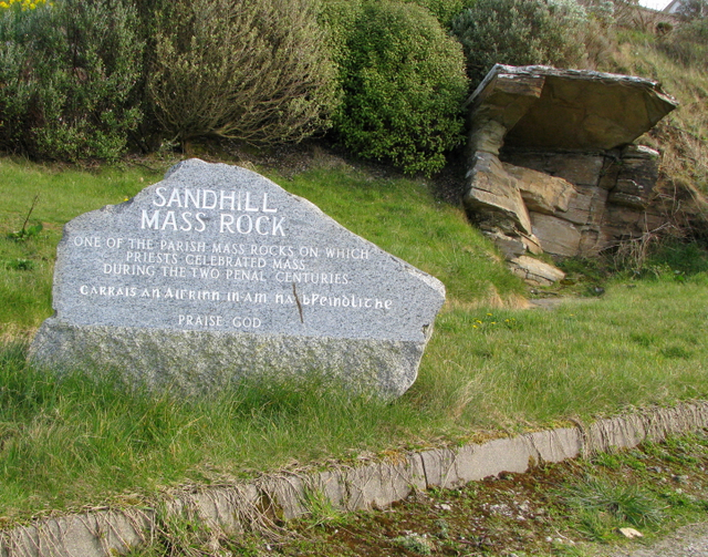
Class: Mass-rock
Townland: SANDHILL
Scheduled for inclusion in the next revision of the RMP: Yes
Description: This stone-built altar like arrangement has been identified as a place where, during Penal times (1690s to 1750s), mass was celebrated. In recent years the site has been marked by a plaque and provided with public access.
Class: Castle - unclassified
Townland: WOODHILL (Kincraigy ED)
Scheduled for inclusion in the next revision of the RMP: Yes
Description: This area is marked McSwyne's Castle on the 3rd edition of the OS 6-inch map. There is a local tradition that the castle stood on an elevated platform of rock here. No trace of the castle now exists. Its reported position is a commanding one in grazing land marked by the occurrence of rock outcrop. The precise location of this castle has not been identified, the placename 'Mc Swyne's Castle' on the OS 6-inch map extends over a large area of rock outcrop, the castle if there was one at this location may have been located somewhere within the vicinity of this placename. In 1943 the ITA Survey recorded, there was a 'tradition that a castle of the Mac Swynes stood on a large rock at the back of Stewarts house in Woodhill (SMR File). The Donegal Survey recorded that a 'local woman (Miss Stewart) described an elevated platform of rock as being the site of "Castle Suibhe". According to Miss Stewart there was no trace of the castle during her grandfathers lifetime' (SMR File).
The proposed development at Sandhill, Dunfanaghy, consisted of a house, garden and car parking area. As part of the planning conditions, an assessment was requested due to the site’s close proximity to the site of McSwyne’s Castle, DG016–020----. Testing was carried out by Eoin Corcoran, Archaeological Development Services Ltd, under licence No. 07E0353 as per the planning condition. No archaeological features, deposits or artefacts were identified during testing. The site appears to have been quarried out in the past and all deposits noted during the testing consisted of dumped material over bedrock. Therefore any potential archaeological material that may have existed on the site was removed during the quarrying process. Documentary sources also indicate that the classification of the site as a castle was based on local tradition rather than extant remains. Cartographic evidence also does not indicate the presence of a castle at the site (Bennett 2010, 82).
There is another McSweeny's castle in Donegal, southwest of us, and the website gives a little history of those local kings.
Class: Crannog
Townland: WOODHILL (Kincraigy ED)
Scheduled for inclusion in the next revision of the RMP: Yes
Description: An apparently artificial island in Sessiagh Lake constructed of stone 18.8m N-S and 20m E-W. On top of the created platform is a subcircular drystone enclosure faced on both sides surviving up to 1m high in places and 0.8m wide. The wall is set in about 1m from the edge of the island. At the N interior is a lintelled drain-hole. At the NE end of the island is a stone landing stage 2.5m × 1.9m which appears to be contemporary with the enclosure.
Crannogs are artificial islands in small lakes built from the 400 to 1100, according to this website, where I found this picture.

This cashel looks to be behind some houses, and it may be easy to walk to.Class: Ringfort - cashelTownland: AN FHOTHAIR (TC An Ardaidh)Scheduled for inclusion in the next revision of the RMP: YesDescription: A grassed-over, collapsed stone wall encloses a sub-circular area except on the S side. The interior is level. It is situated on a rock spur close to the E shore of Sessiagh Lough. To the N there is marshy rocky land, to the S higher ground with good grazing.
Class: Burial groundTownland: AN FHOTHAIR (TC An Ardaidh)Scheduled for inclusion in the next revision of the RMP: YesDescription: Marked 'Mullaghadoney Burial Ground' on the 2nd and 3rd editions of the OS 6-inch maps. The site now consists of a group of stones, presumably grave-markers. One of these, .85m high, .7m wide and thick has a hole c. 3cms in diameter close to its W edge, at mid-height. The site, in grazing land, is a flat-topped rise with good views.
Burial grounds sometimes all that remain of an earlier megalithic monument. Any sacred place can become a memorial ground.
Class: House - 16th/17th century
Townland: AN FHOTHAIR (TC An Ardaidh)
Scheduled for inclusion in the next revision of the RMP: Yes
Description: Faugher House: In 1611, Tirlagh Roe O'Boyle was granted some 2,000 acres in the barony of Kilmacrenan which included, inter alia, the lands of Faugher. In 1619 O'Boyle is described as having 'built a good bawn and a house of lime and stone in which he with his family dweleth' . He mortgaged the lands to John Stanton, whose wife is recorded as living there in 1622. The house is described in that year as 'of clay and stone rough cast with lime, 48 ft long, 25 ft broad and 13 ft high . . . Adjoining to this house, there are 3 stone houses and a timber house, thatched' . The lands were forfeited by O'Boyle as a result of the 1641 rebellion. They were regranted to Sir John Stephens and were sold by his assignee, Hugh Hamil, to William Wray in 1700; the Wrays had been living there for some 30 years previous . The house was abandoned during the 18th century and is marked as 'Castle Ruins' in Taylor and Skinner (1778, 231).
The Big House belonging to successive landlords, abandoned 200 years ago. This one is in the middle of someone's farm and an estate of holiday homes.

Class: Bullaun stoneI wonder if someone around here knows where this is.
Townland: AN FHOTHAIR (TC An Ardaidh)
Scheduled for inclusion in the next revision of the RMP: Yes
Description: We regret that we are unable to supply descriptive details for this record at present.
Class: Megalithic structure
Townland: AN FHOTHAIR (TC An Ardaidh)
Scheduled for inclusion in the next revision of the RMP: Yes
Description: Marked in gothic script on current edition of the Ordnance Survey map as 'Lacknaloe'.

This is the map west of our house. I've visited the Old Church, but not the tomb or the ring fort.
Class: Penal Mass stationThe last time I was here, I didn't know to look for this...whatever it is.
Townland: KILL (Dunfanaghy ED)
Scheduled for inclusion in the next revision of the RMP: Yes
Description: This feature, listed by Borlase (1897) as a possible 'dolmen', was later described as a 'prehistoric chamber tomb' (Killanin and Duignan 1962; 1967). It is a masonry platform built against the enclosing wall of an old burial ground. According to an OS 1:2,500 Name Book (1905), clergymen, when officiating at burials, stood at this spot to collect death offerings.
There are two graveyards here. One for the Catholics, one for the Protestants.

Class: Church
Townland: KILL (Dunfanaghy ED)
Scheduled for inclusion in the next revision of the RMP: Yes
Description: Clondahorky Old Church: Described in 1622 as 'newly re-edified and well repaired' (Royal Commission, 215), the church continued in use until a new one was built at Ballymore in 1752 (Rowan 1979, 123). This early 17th century ruined church, 17.25m by 5.6m internally, is built of rubble with small pinnings. The walls are entire and both gables retain coping; the western is crowned with a simple bellcote. The E gable has a blocked-up segment-headed window with splayed ingoings and there are two smaller similar windows, also blocked-up, in both the N and S walls; the windows were timber-framed. The door-way at the W end of the S wall had a timber lintel (now missing) and segment-headed rear-arch. Sections of plaster survive on the interior wall-faces and the 'exposed masonry of the N wall and SW corner is fire damaged.

Class: Graveyard
Townland: KILL (Dunfanaghy ED)
Scheduled for inclusion in the next revision of the RMP: Yes
Description: Clondahorky Old Church (DG015-017-): Described in 1622 as 'newly re-edified and well repaired' (Royal Commission, 215), the church continued in use until a new one was built at Ballymore in 1752 (Rowan 1979, 123). This early 17th century ruined church is located in the N quadrant of a rectangular graveyard (approx. dims. 50m E-W x 25m N-S).
There is another Catholic cemetery at some distance from the church and its burial ground. In between them is a walled area labeled the "famine burial ground."


The Church's silhouette against the horizon would have been visible from Sheephaven Bay.
Class: Megalithic tomb - unclassifiedSadly, I've read many descriptions of lost monuments just like this one. This one seems like it much larger than other "Diarmuid and Gráinne's Bed" sites I've visited. Those other sites are much smaller, more like dolmans, than court tombs.
Townland: RINCLEVAN
Scheduled for inclusion in the next revision of the RMP: Yes
Description: This feature was named 'Labba' on the original OS 6-inch map (1834) and on the revised 6-inch map of 1847-9. There is now no trace of it. It is described in an OS Name Book (1834) as 'a small collection of stones eight in number' said to have been a temporary residence for a husband and wife, a reference, it appears, to the Diarmuid and Gráinne legend.
According to Thomas Fagan (1845-8), the structure was removed in 1842. On the basis of local information gleaned on his visit to the area in 1845 he concluded that it was a 'Druidical sepulchre' of the type known to the people as 'Dermot and Grania's Bed' and that it had occupied a space 40 feet (c. 12.2m) by 20 feet (c. 6.1m) inside 'a parapet of earth and stone' and had consisted of 'sundry vaults or graves' built of large stone slabs 2-5 feet (c. 0.6-1.5m) high. A central 'vault' measured 10 feet (c. 3.05m) by 6 feet (c. 1.8m) and was covered by a single great flag. The other graves were of 'minor size', but there is no information about their number or position relative to the so-called central vault. On the destruction of the monument, 'shin, thigh and other human bones of large size' were reportedly found, as well as over three cartloads of sea shells and two 'brass' spears each c. 18 inches (c. 0.45m) long, 'one embracing the handle by a socket and the other by straps'. Many other finds of 'minor order' were lost by local children. The floors of the graves were said to have been paved with large and small stones.
Although the monument appears to have been some form of chambered burial site, its nature remains uncertain.
Here's a version of the legend mentioned above.
The Pursuit of Diarmuid and Gráinne is tale that storytellers adapted by adding their own local megalithic tombs to the story. As Fionn Mac Cumhail (Fin MacCool) chased the couple around Ireland, they were forced to sleep in a different place each night. Now known as "Diarmuid and Gráinne's Bed," if a woman sleeps in one of them today now, she will become more fertile. Or maybe they are just convenient and secluded place to have sex?

The sites on this map are all less than an hour's drive away. I don't need to visit all of them, but I never get tired of driving down a narrow lane in search of them.
No comments:
Post a Comment